Photo: nature.piktureplanet.com
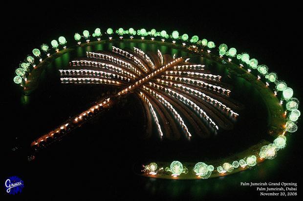
Palm Jumeirah, Dubai, UAE
While many islands are known for their natural beauty, there are islands dotting the world’s seas that were formed by man rather than Mother Nature. Some of these man-made islands were created for flood protection, some were developed for tourism and others serve as wildlife sanctuaries. While many of these creations are true feats of engineering, there have been reports on the ecological impact of some of these artificial islands. Dubai’s mega-projects such as the World Islands and the Palm Jumeirah, for example, are projects “so substantial that they have changed the ecology in ways that are only going to become clear in decades,” said Peter Sale, a marine ecologist at the United Nations University (UNU) Institute for Water, Environment and Health who co-authored a report on the impact of development of the Gulf.
Part of the planned Palm Islands, a cluster of “manufactured” islands in the United Arab Emirates, Palm Jumeirah is an artificial archipelago designed in the shape of a palm tree. It consists of a trunk, a crown with 16 fronds, and a surrounding crescent island that forms an 6.8-mile-long breakwater and is now the home of the luxury resort Palm Atlantis Hotel. Construction on the Palm began in 2001, and it added 40 miles to Dubai’s coastline. Once complete, the island will have hotel rooms and homes for 65,000 people, according to Guardian.
The Palm was created using 7 million tons of rock, according to its developer Nakheel. The island also includes a curved breakwater using natural rock, intended to encourage the creation of a natural reef and provide habitats for sea life. In 2009, the Palm Jumeirah Monorail opened to the public. It’s the first monorail in the Middle East, and connects the trunk of Palm Jumeirah and the Atlantis Aquaventure Station on the crescent and will ultimately connect the archipelago to the mainland.
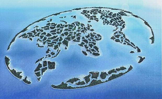
Photo: toptentour.info
The World Islands, Dubai, UAE
Also in Dubai, located 2.5 miles off the coast, another mega-project involving artificial islands will be the location of luxury hotels and homes. Unveiled in 2003, The World is an artificial archipelago of 300 small islands, composed mainly of sand dredged from the shallow coastal waters, to be constructed in the shape of a world map. However, it seems all is not well with The World. The project was delayed in 2008 due to the global financial crisis and as of February 2013, only two of the 300 planned islands (“Greenland” and “Lebanon”) have seen development, according to Gulf News.
In February 2010, images taken from space and posted on NASA’s Earth Observatory website suggest that the islands of The World are merging and sinking, according to the Daily Mail. The images highlighted fears that the islands would be ultimately eaten away by erosion, as they sat undeveloped, while environmentalists warned rising sea levels would eventually sink the million-dollar islands, reported ABC News.
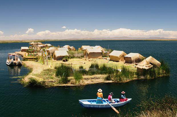
Photo: prositehosting.co.uk
Islands of the Uros, Peru
The Uros people of Peru live on floating islands made from the reed that grow along the edges of Lake Titicaca, Puno. The Uros harvested the reeds, bundled them together tightly and built floating island platforms. Each island has a collection of simple, reed houses and the biggest island has a watchtower, according to Atlas Obscura. The larger islands house about 10 families, while the smaller ones (about 98 feet wide) house only two or three. According to the Spanish Ministry of Industry, Energy and Tourism’s report on Puno, the Uros islands sit at 1,246 feet above sea level and are about 3 miles west from Puno port.
Environmental and health issues are affecting the islands and the culture of the Uros people. “The waters of the Uros have been overfished by commercial fishermen, tourists are affecting their traditional culture and sewage from Puno is causing environmental and health problems,” anthropologist Arrufo Alcantara Hernandez, director of the faculty of social sciences at the Universidad Nacional del Altiplano in Puno, told National Geographic.

Photo: 11weeksinparis.com
Île aux Cygnes, France
Ile aux Cygnes (“Isle of the Swans”), a narrow artificial island in the river Seine in Paris, France was formed in 1872 to protect the port of Grenelle. It is home to a tree-lined walkway, the “l’Allée des Cygnes” that runs the length of the island, and a replica of the Statue of Liberty. Standing 72 feet high and facing west in the direction of its big sister in New York, the monument was gifted to France by the American community of Paris. The statue initially faced east, toward the Eiffel Tower, but it was turned west in 1937 for the World Fair in Paris.
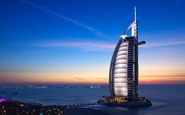
Photo: skywaystours.in
Burj Al Arab, Dubai, UAE
A towering 1,053 feet, the Burj Al Arab dominates the Dubai skyline as the fourth tallest hotel in the world. It stands on an artificial island 920 feet from Jumeirah beach, connected to the mainland with a private curving bridge. To secure a foundation on the island, the builders drove 130-ft long concrete piles into the sand, according to EgyptEng.com. Engineers created a surface layer of large rocks, circled with a concrete honeycomb pattern, which serves to protect the foundation from erosion. Unveiled in 1999, it took three years to reclaim the land from the sea, while it took fewer than three years to construct the building itself, which was designed to resemble the sail of a ship.
The Burj Al Arab houses some of the most expensive hotel suites in the world — all suites are arranged over two floors and have whirlpool baths,living and dining areas and dedicated butlers, according to CNN. One of the suites, the Royal Suite, costs about $18,716 per night.
Photo: framepool.com
Danube Island, Austria
A long, narrow island, in central Vienna, Austria, between the Danube river and the parallel excavated channel Neue Donau (“New Danube”), Danube Island (or Donauinsel) is home to clubs, bars and restaurants and a popular music festival. While locals flock to the artificial island to enjoy open-air events, the Danube Island was built as part of Vienna’s highly sophisticated flood protection system. As the Danube river crosses the city, flooding has long been a concern for Vienna.
Construction of the island began in early 1970s. Excavation material was dumped between the New Danube and the existing river bed to create 13 miles of artificial island. The flood control system is designed to protect from flash floods bringing river flows of up to 14,000 cubic meters per second. This has only happened once in Vienna’s history in 1501; the heavy 2002 flood brought flows of 10,000 cubic meters per second.
Close to 2 million trees and bushes were planted between 1974 and 1988. Today, the island is divided into three section, natural areas in the north and south and a city-park area in the center.
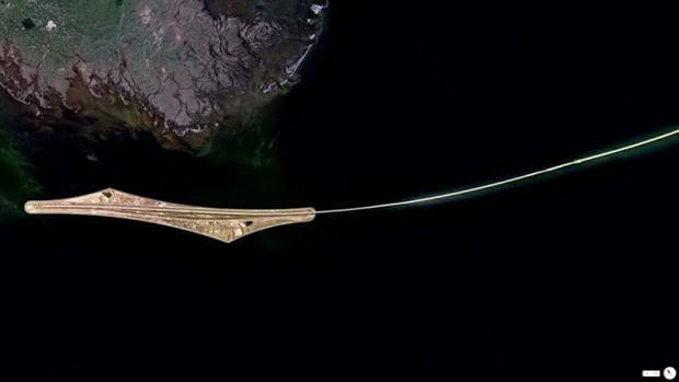
Photo: pinterest.com
Peberholm, Denmark
The construction of the Oresund Bridge connecting Denmark with Sweden included the construction of Peberholm, an artificial island in the Danish side of the Oresund. The island was built to serve as a a crossover point between the tunnel and the bridge. The tunnel had to be built since a bridge spanning the entire link between Malmö, Sweden and Copenhagen, Denmark would have interfered with obstacle-free zones around Kastrup Airport. A tunnel would also allow large ships to pass the Oresund without worrying about the height of the bridge.
Officials built Peberholm with ecology preservation in mind. The location, for example, was chosen since it would ensure the freest flow of water through the sound. Scientists also predicted that nature would colonize the island, without any human interaction (only biologists are allowed beyond the freeway and railway routes). As of June 2007, scientists from the Biological Society of Lund had registered 454 species of plants on the island. The island is also home to 8-10 breeding species of birds and rare spiders, according to Birds-of-Denmark.
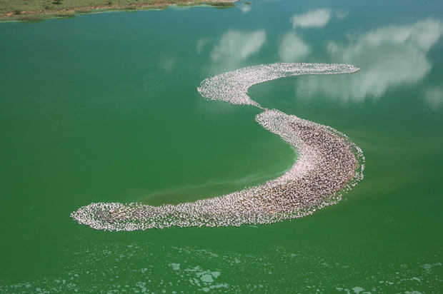
Photo: telegraph.co.uk
Kamfers Dam, South Africa
An artificial “S” shaped island located behind Kamfers Dam, north of Kimberley, South Africa, has been an important breeding sanctuary for Lesser Flamingos since its construction in September 2006. Up to 50,000 flamingos, a large proportion of the subregion’s total population, flock to the dam, according to an article in Africa – Birds and Birding. Ornithologist Mark D. Anderson, who oversaw the construction, enlisted the help of a local company Ekapa Mining, who moved 26,000 tons of material to create the island.
Unfortunately, the flamingos are in danger of losing their breeding island. Deteriorating water quality and increasing water levels make Kamfers Dam progressively more unsuitable for Lesser Flamingos, according to GetBirding.com. Not only is the water quality the worst it has ever been, but the water is now at its highest level ever. More than two-thirds of the Lesser Flamingo breeding island remains flooded, and two important railway lines are at risk.
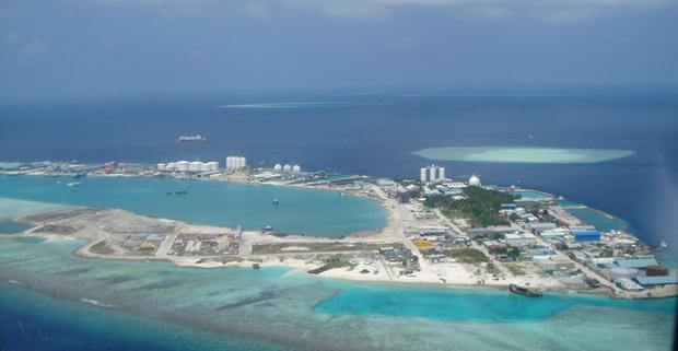
Photo: wikipedia.org
Thilafushi, Maldives
The Maldives are known for their stunning natural environments and white beaches, the reason millions of tourists flock to their luxury resorts every year. Of its 200 inhabited islands, 99 are dedicated resorts, according to the Daily Mail. One of its islands is Thilafushi, an artificial island built on reclaimed coral reefs in 1992. It doesn’t house a five-star hotel, however. Thilafushi was built to serve as a municipal landfill, and was thus nicknamed “Garbage Island.”
Located to the west of Malé, between Kaafu Atoll’s Giraavaru and Gulhifalhu, Thilafushi is dumping ground for more than 300 tons of rubbish. ?In 2005 it was estimated that 31,000 truckloads of garbage are transported to Thilafushi annually, where it is dumped in large piles and eventually used to reclaim land and increase the size of the island, according to the International Red Cross and Red Crescent Societies. The Guardian reported that so much is being deposited that the island is growing at 10 square feet a day.
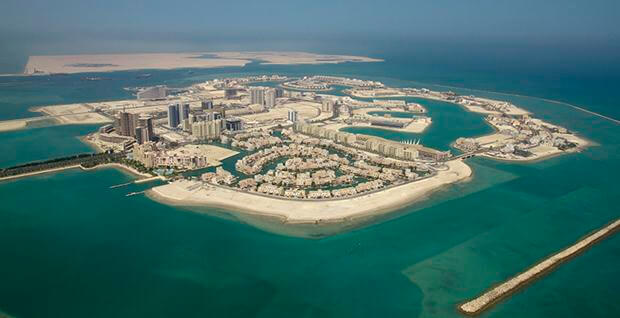
Photo: meritas.bh
Amwaj Islands, Bahrain
A group of planned man-made islands located in the northeast of Bahrain, near the coast of Muharraq island, the Amwaj Islands cover roughly 30 million square feet. They are a pioneering project in Bahrain, the first to offer 100 percent freehold land ownership to expatriates living in the Kingdom of Bahrain.
The Amwaj Islands project began in 2002; islands were reclaimed from the relatively shallow seas to the northeast of Muharraq Island, the northernmost island in Bahrain. To protect the new development from storms and erosion from the sea, a broad-crested breakwater reef has been constructed around the island from the west to the east on the northern side, according to DesignBuild-Network. ?The key element in the design of the project was the use of the sand and stone-filled “geotubes” to form the island perimeter. The Islands contain residential, commercial and hotel and retail buildings, and a “floating city” reminiscent of Venice named Al Marsa, according to ArabianBusiness.com.
Source: weather.com